Hello!
Quick question, when running a static simulation with gravitational body forces and reference stresses on a 2D domain that looks like this:
Would I set up the reference stresses from 0 to 40 km in the crust and from 35km to 60 km in the mantle in my spatialdb files?
For example crust_gravity_refstate.spatialdb:

For example mantle_gravity_refstate.spatialdb

Best regards,
Eddie
With the crust-mantle boundary not being exactly horizontal, I am not aware of an analytic solution for a reference stress state that will exactly balance the gravitational body forces. I think a reasonable approximation for a reference stress state is to use lithostatic pressure from an average 1D profile. In this case, I would compute the reference stress state using crustal properties for 0-37.5 km depth and mantle properties for 37.5 km and deeper.
The crustal spatial database would need to go from 0-40 km deep, and the mantle spatial database would need to go from 35 km and deeper. For example, the crustal spatial database would include the material properties only for the crust, but the reference stress state would match an average 1D profile that included both crustal and mantle properties down to 40 km depth. A spatial database can extend beyond the boundaries of the region where it is applied, so it is not a problem for the crustal and mantle spatial databases to have regions where they overlap. The crustal spatial database is only applied in the region with cells for the crustal material, and the mantle spatial database is only applied in the region with cells for the mantle material.
Alternatively, you can try to create a 2D reference stress state that balances the lithostatic pressure in every 1D depth column across the domain.
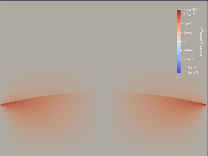
I’m visualizing the results in paraview and I see that there are very high shear stresses at the edges:
Is this correct or did I do something wrong?
For the crust reference stresses at 40 km depth I did:
(rho_crust ⋅ g ⋅ z) + (rho_mantle ⋅ g ⋅ z)
(2800 ⋅ 9.81 ⋅ 37.5 ⋅ 1000) + (3300 ⋅ 9.81 ⋅ 2.5 ⋅ 1000) = ~ 1.75 ⋅ 10^9 Pa
and then I used that value as the reference stress at 35 km depth in the mantle spatialdb file and then computed the lithostatic pressure to 60 km depth as well.
How many depths do you have in your spatial database file? The reference stress changes slope at the depth where you transition from crust to mantle in your average 1D profile, so you need points in your spatial database file at these depths. This results in piecewise linear profiles. With just 2 points (depths) in the spatial database, the variation will be linear, which is not what you want.
That makes sense! I fixed it and added 3 depths to each spatialdb file, and those shear stresses have reduced significantly, thank you:
Max shear stresses are now ~2 MPa.
![]()
![]()


